DRIVE:
WEE THUMP EAST DRIVE
Type: One-lane backcountry road.
Total Length: 11.2 miles. 15.2 miles if the recommended side detour is taken.
Road Surfaces: Gravel with some short rocky and sandy sections.
Vehicle Type: A 4-wheel drive vehicle with clearance is recommended.
Difficulty: Moderate, but a few small tricky spots.
OVERVIEW
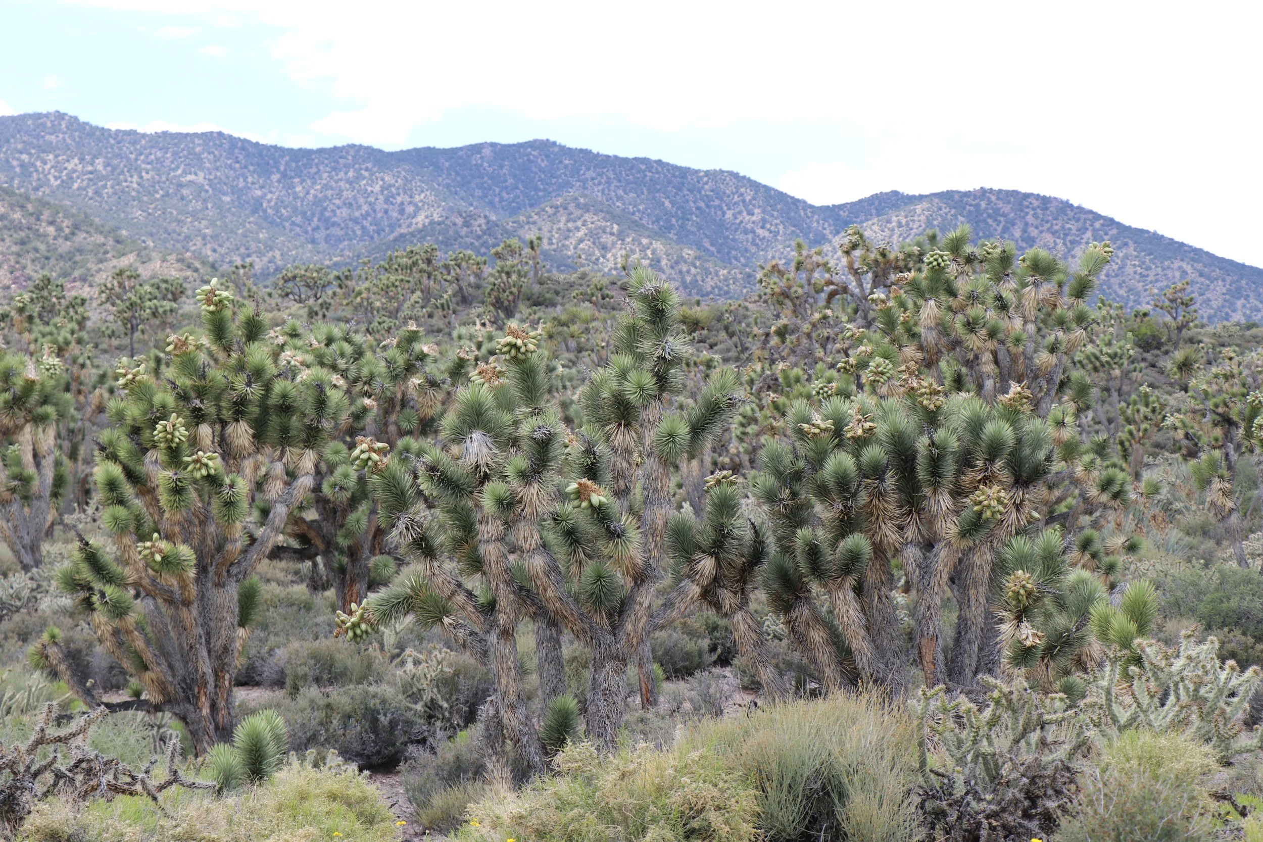
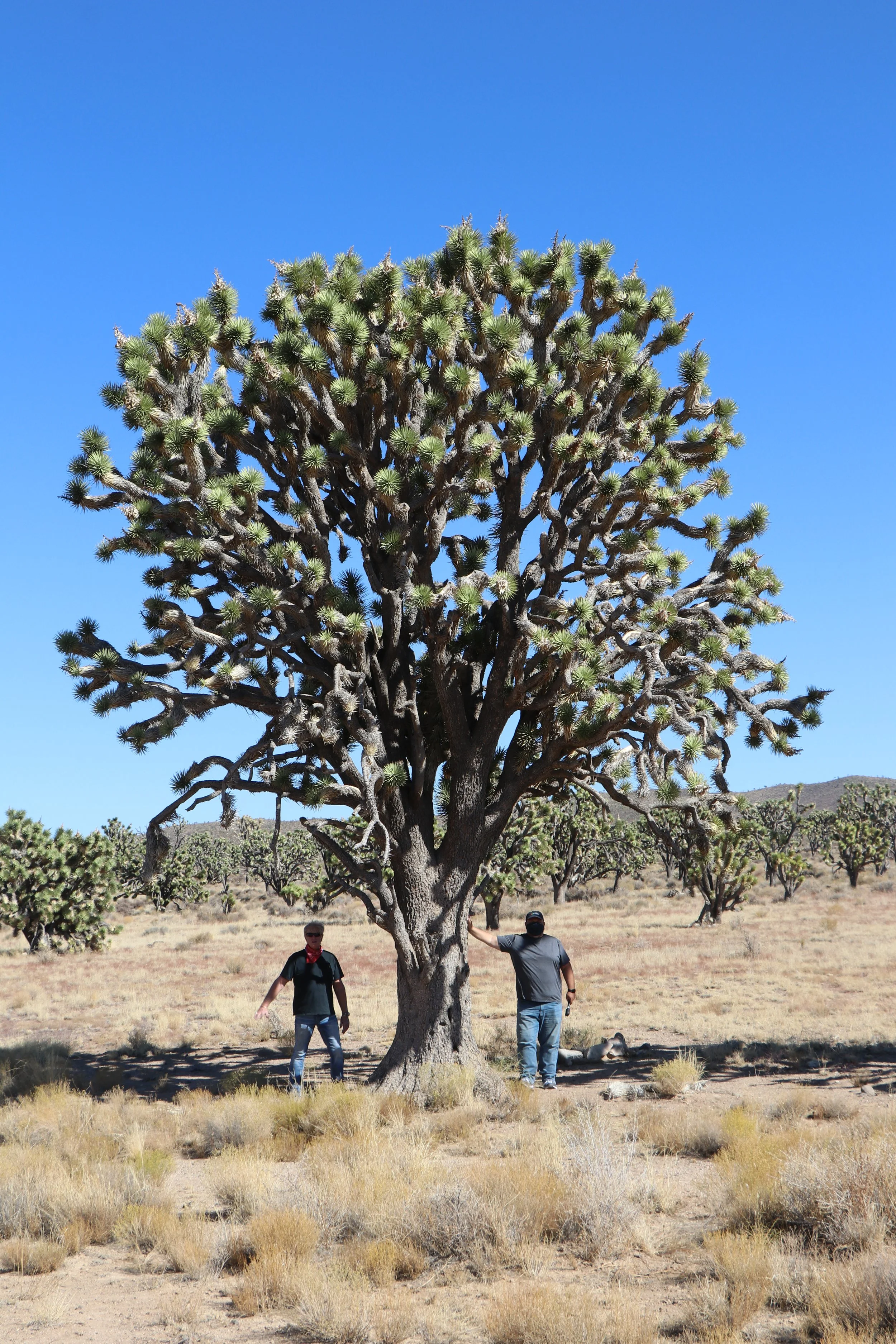
This drive travels through a remarkable Joshua tree woodland landscape, a transitional zone where the high and low deserts meet. Joshua tree woodlands are one of the Mojave Desert’s signature habitats: vast, open country shaped by the presence of these iconic trees that define the character of the landscape. Along the entire route, Joshua trees rise from the plateau, with some towering nearly 30 feet tall and estimated to be between 300 and 900 years old—living witnesses to centuries of desert change. Beyond the Joshua trees, the route reveals an exceptionally diverse and resilient desert ecosystem. The area is celebrated for its dense, high-quality understory of native bunch grasses and low-growing shrubs, creating a rare sense of abundance in the Mojave Desert. Since historical grazing permits were canceled in the 1990s, these fragile native communities have steadily recovered, restoring a landscape where grasses once again anchor the soil, reduce erosion, and provide essential habitat and shelter for the federally threatened desert tortoise. These sweeping grass-covered plains give this high-elevation plateau a distinctive character—an unexpected “grassy desert” that feels both expansive and timeless.
One of the defining features of this drive is the breathtaking sense of openness and the sweeping views across the Mojave Desert. Looking southeast, the rugged Newberry Mountains rise above the desert, including the sacred summit of Spirit Mountain (Avi Kwa Ame). To the southwest, the dramatic Castle Peaks and Castle Mountains frame the horizon. Farther west, the distant New York Mountains emerge across the desert, while to the north the southern end of the Highland Range completes the panoramic view. Together, the ancient Joshua trees, recovering native grasslands, and endless mountain horizons create a journey through one of the Mojave’s most distinctive and awe-inspiring landscapes.
ROUTE DETAILS:
About the Route: The drive starts 3.6 miles west of the intersection of U.S. 95 South and Nevada Highway #164 in Searchlight. There is a backcountry road that takes off of highway #164 at coordinates 11S 683280m E3928440mN. The road goes through a break in the fence here.
Mile 0.0: After 50 feet, the road immediately takes a sharp right following the fence line for 100 yards and turns left through a gap in the fence.
Mile 0.3: There is a series of conical shaped volcanic peaks looking east. Note the black lava flows between spaces not covered in grasses.
Mile 0.5: This drive passes through some of the most important desert tortoise habitat in Nevada, supporting some of the highest known concentrations of this iconic Mojave Desert species. The desert tortoise is a federally protected threatened species, and these intact protected desert landscapes within Avi Kwa Ame National Monument provide the food, shelter, and space it needs to survive. Protecting these habitats is essential to ensuring that desert tortoises continue to thrive here for generations to come.
As you drive this route, a few simple actions can help protect these remarkable desert residents. Please slow down and stay alert while driving—vehicle strikes are one of the leading causes of injury and mortality for desert tortoises. In other words, drive tortiously. If you are fortunate enough to encounter a tortoise along the road, please do not pick it up or move it unless it is in immediate danger. Desert tortoises store water in their bodies to survive the harsh desert environment, and when handled, they may release their stored bladder water as a stress response. Losing this precious water can be life-threatening, especially during the hot, dry months when water is scarce. The best way to help a tortoise is to admire it from a respectful distance and allow it to continue its journey through the landscape it has inhabited for thousands of years.
Mile 1.0: Along this stretch of the drive, the understory vegetation consists primarily of drought-adapted shrubs and succulents, including creosote bush, Mojave and banana yucca, blackbrush, and white bursage. Cacti species such as buckhorn cholla, silver cholla, beavertail and prickly pear are prevalent as well. You will also notice that there is an abundance of native grasses mixed within the understory along the entire route. There are also hillsides in places covered almost exclusively with native grasses with only scattered Joshua trees, yuccas and cacti growing. The grasslands and washes along this route contain a remarkable mix of drought-adapted native grasses. Species such as big galleta and fluffgrass are warm-season C4 grasses that can awaken almost overnight following summer monsoon storms, taking advantage of brief pulses of moisture during the hottest months of the year. They are able to rapidly activate growth when moisture becomes available because their tissues remain dormant but viable through the dry season. Within days, dormant leaves can expand, new shoots emerge, and the landscape can shift from brown to green. Other native grasses, such as Indian ricegrass and desert needlegrass, are cool-season C3 species that grow during the cooler winter and spring months.
Together, these C4 and C3 grasses reflect the remarkable strategies desert plants use to survive in one of North America’s most challenging environments. That seasonal contrast is actually one of the more interesting ecological stories of the Mojave. This means that driving this route will look different depending on the season. A notable ecological benefit of these healthy native grass communities is their resistance to invasive grasses. While many desert regions suffer from heavy infestations of invasive Red Brome or Cheatgrass, the dense native cover along this route has kept these invaders largely at bay.
Mile 1.9: Looking northwest, you can see the South McCullough Mountain Range in the distance, which rise to over 7,000 feet. Most of the McCullough Range at the higher elevations is forested with pinyon pine and juniper woodlands.
Mile 2.5. There is a backcountry road on the right. Stay straight. Beyond the Joshua trees and open desert grasslands, this route passes through a landscape used by one of the Mojave’s most iconic animals, the desert bighorn sheep. The wide-open views along this drive reveal more than scenery—they reveal a living landscape where wildlife continues to follow ancient pathways across the Mojave. Although Desert Bighorn Sheep are often associated with rugged mountain peaks, bighorn sheep depend on the spaces between mountain ranges as much as the mountains themselves. The area traversed by this drive provides important connections between the Castle Mountains, New York Mountains, Highland Range, and South McCullough Mountains, allowing sheep to move across the desert in search of water, food, and seasonal habitat.
In addition to Desert Bighorn Sheep, mammalian residents include, among others, coyotes, black tailed jackrabbits, desert cottontails, kit foxes, bobcats, and an occasional mountain lion. It is very common to see some of the smaller mammal species such as the white-tailed antelope ground squirrels scampering across the road. This is a rodent ubiquitous in the Mojave that’s often mistaken for a chipmunk. They are voracious collectors of Joshua tree seeds. The squirrels have no trouble reaching fruit on even the highest branches. They can easily chew through the overripe fruits’ spongy mesocarp, releasing the seeds. They then distribute many of those seeds into caches secreted around the landscape, and when they inevitably forget where some of those cached seeds are, those seeds can germinate and create a new generation of Joshua trees. They are skilled diggers that create complex underground systems for protection and nesting.
Another important point about the area traversed by this drive and the adjacent Wee Thump Joshua Tree Wilderness Area, is that it was designated by National Audubon and Bird Life International as an “Important Bird Area,” a national designation recognizing its importance for bird conservation. This rich, diverse habitat supports more bird species at higher densities than most other desert habitats. Avion species encompass resident and migratory forms, such as greater roadrunners that hunt lizards and insects across open ground, and Gambel’s quail that forage in shrubby areas. Raptors like hawks and golden eagles patrol for prey, while smaller birds including northern flickers, curvedbilled thrashers, loggerhead shrikes, and cactus wrens utilize Joshua trees for nesting and perching. Gilded flickers, known in Nevada only from this general location, also frequent the area. The Bendire’s Thrasher and LeConte’s Thrasher are also found in the area. Both of these trashers are species of concern for possible listing on the Endangered Species list because of declining populations. Avi Kwa Ame’s designation as a national monument helps ensure that their breeding habitats are protected for generations to come.
Mile 2.6: The road crosses a wash area, one of several along the route. These desert washes (arroyos) are normally dry channels that come alive during seasonal rains. Although water may only flow here during storm events, these washes play an important role in the desert ecosystem. Their deeper soils and access to underground moisture allow certain plants to thrive, creating pockets of vegetation that are often more diverse and different from the surrounding landscape.
These washes are places where the desert tells its story: where the unseen presence of water shapes vegetation and provides refuge for wildlife. If you are willing to step out of the vehicle and explore on foot, the washes offer a closer look at the subtle ways water shapes the Mojave and reveals the surprising diversity hidden within this seemingly dry landscape and creates opportunities for visitors to slow down, step outside, and discover the remarkable richness of life hidden in the Mojave.
Look closely and you may notice taller shrubs and small trees such as catclaw acacia, desert willow, mesquite, and other wash-adapted plants that create pockets of greater diversity and provide important habitat for wildlife. These desert corridors reveal one of the Mojave’s greatest lessons: even in a landscape defined Catclaw Acacia with debris from flood water Mesquite teee in wash Desert Wash 228
Mile 5.3: Eroded area, Stay to the right. The Joshua trees along this section are denser than the first part of the drive.
Mile 5.5: Here you get a good view of the south end of the Highland Range which rises dramatically above the surrounding desert valleys. The Range does not have the iconic name recognition of Spirit Mountain (Avi Kwa Ame) or the Joshua tree forests of Wee Thump, but it is a remarkable example of the Mojave Desert’s mountain ecology. It forms a rugged mountain corridor in the central portion of the monument, separating the Piute Valley to the east from the Eldorado Valley to the west. The range is part of the larger interconnected mountain-and-valley system that makes Avi Kwa Ame such a biologically and culturally significant landscape. The northern portion is especially rugged, with steep peaks and canyons rising more than 1,500 feet above the surrounding terrain.
One of the Highland Range’s greatest values is its role as habitat and a movement corridor for wildlife, particularly for the Desert Bighorn Sheep. The Highland Range is critical habitat for the Desert Bighorn Sheep. The range is part of a larger network connecting the Piute Mountains, New York Mountains, Castle Mountains, South McCullough Mountains, Newberry Mountains, and Eldorado Mountains. While Avi Kwa Ame is named for the sacred Spirit Mountain landscape, the importance of the monument is that it protects an entire interconnected cultural landscape—not just one mountain. The Highland Range is part of that larger story: mountains, valleys, springs, wildlife corridors, travel routes, and places of ancestral connection that have meaning across generations.
Mile 5.7: Ridgeline and end of this section of the route. Turn around at this point and head back on the road you just traveled. Beyond this point, the road has a rough, rocky section and is not recommended for travel unless you are an experienced OHV driver with 4-wheel drive and good off-road tires. However, it
by scarcity, water leaves a lasting signature on the land. They also function as natural corridors for wildlife, providing food, shelter, and movement routes through an otherwise dry landscape.
Mile 3.22: Road crosses another wash. Looking east, there is an extensive lighter colored rock formation in the mountain range mixed in with the darker volcanic rock. Mile 3.6: There is a junction with another backcountry road. Take a right.
Mile 3.8: Another junction with a backcountry road. Take a left. Note: The other road that takes off to the right offers an excellent detour route that accesses some interesting terrain and diverse vegetation which can be taken on your way back as you will be backtracking to this point once you end up at the ridgeline overlooking the Highland Range.
Mile 4.0: Larger wash crossing with some sand. Looking south, you can see Spirit Mountain (Avi Kwa Ame) in the far distance. This is one of the washes along the route that you might consider taking a stroll down the wash for a half mile to check out some of the vegetative communities.
Mile 4.63. First views of the south end of the Highland Range. Lots of native grasses with some slopes dominated by grasses.
Mile 5.2: Historic grazing coral. For more than a century, these desert valleys supported livestock operations that were part of the region’s human history. As scientists learned more about the importance of this landscape for the desert tortoise and other wildlife, conservation efforts began acquiring grazing interests and protecting habitat. This allowed conservation organizations and agencies to retire grazing use and reduce pressure on sensitive habitat. The result is a landscape where ranching history and conservation history overlap—where the recovery of native vegetation and wildlife is now part of the ongoing story of Avi Kwa Ame.
Mile 7.6: (Note: this is the intersection with the backcountry road mentioned earlier that makes for an excellent detour drive. If you are taking the detour, turn left. The drive is 2 miles one way or 4 miles round trip if you go the full length. There is a beautiful desert wash that follows much of the first mile of the drive. This is another spot that you may want to get out of the vehicle and walk part of the wash. There is rich and diverse habitat both in the wash and adjacent areas. There are some desert willows, mesquite, and catclaw acacia in the wash and lots of bird activity. In the adjacent area is a robust stand of Joshua trees, buckhorn cholla, barrel cactus, and both Mojave and banana yuccas. This is an excellent area for bird watching.
There are also pockets of Sonoran scrub oak near the end of the detour route. A scrub oak stand is almost like a biological island. Oaks are survivors from wetter climatic periods and persist where mountains create small pockets of favorable conditions. These locations become miniature “islands” of higher productivity surrounded by much drier desert vegetation. Its dense evergreen foliage offers shade and thermal refuge during extreme heat, providing nesting habitat for birds and escape cover for reptiles and small mammals. In desert ecosystems, structure is everything. A shrub that creates shade and shelter can support an entire community of organisms. Like all oaks, scrub oak produces acorns. Those provide an important seasonal energy source for wildlife, including rodents, birds, and larger mammals. Animals also help disperse acorns, allowing new oak patches to establish.
About 1.5 miles into the detour route, you pass a wildlife water guzzler. This is one of five guzzlers along the Wee Thump East Loop route. In the extremely arid Mojave Desert, natural water sources like springs and tinajas (rock pools) can dry up. Guzzlers act as a vital lifeline for a variety of species, ranging from desert bighorn sheep and mule deer to birds (like quail and chukar) and small desert reptiles. There are several types of guzzlers. This one is a small game guzzler.
Small game guzzlers have a smaller catchment footprint designed to support upland game birds, rabbits, and smaller wildlife. These guzzlers often feature a large, flat ground apron made of concrete, sheet metal, or plastic. They lead to an underground storage tank. Animals access the water via a narrow, descending ramp designed specifically so small mammals, birds, and reptiles can walk down to drink without slipping into deep water. Big Game Guzzlers are larger catchments tailored primarily for desert bighorn sheep and mule deer. There are none along this drive, but there are several in the northern part of the Highland Range. These require large aprons and extensive underground storage. Because both the small and large game guzzlers require constant upkeep—clearing gutters, repairing fiberglass aprons, and hauling water by helicopter during extreme dry periods—conservation groups frequently rely on volunteer labor.
The end of the detour drive leaves you directly adjacent to the mountain slope with the beige colored rock formations. This is also a good place to get out of the car and hike among the rock formations and take in the expansive views and diverse habitat. Mile 7.6: If you do not choose to take the detour route, turn right on the backcountry road. Mile 8.3: Wash crossing. You start getting great views of the saw-toothed-looking Castle Peaks and volcanic Castle Mountains looking southwest.
Mile 8.5: Another wash crossing.
Mile 8.9: A small 50-yard tricky rock section. Just proceed slowly.
Mile 9.1: Wash crossing. You start getting long-distance views looking southeast of Spirit Mountain (Avi Kwa Ame). You are now in a pretty dense Joshua tree woodland environment with a rich understory, including a variety of native grasses
The colorful patches growing on the some of the rocks along the drive are not stains or minerals—they are living communities of lichen, partnerships between fungi and photosynthetic organisms that survive some of the harshest conditions on Earth. Growing at an almost imperceptible pace, lichens weather rock, build soil, recycle nutrients, and provide the first foundation for life in the desert. These small organisms remind us that even the most barren-looking landscapes are alive and constantly changing. Mile 9.2: There is a junction with another backcountry road. Stay right.
Mile 9.3: Another wash crossing.
Mile 10.8: Junction with another backcountry road. Stay left.
Mile 11.2: End of route and junction with Nevada Highway #164
Know Before You Go:
KNOW BEFORE YOU GO:
This route offers a true backcountry desert experience, where the rewards of solitude and scenery come with the responsibility of being prepared. The desert is a place of remarkable beauty and resilience, but it is also a landscape where preparation matters. Taking the time to be really prepared allows visitors to safely enjoy the wide-open views, wildlife, and quiet solitude that make this route special. This is a remote desert route, and visitors should come prepared. Cell coverage is limited, services are far away, and road conditions can include rocky, rough, and eroded sections. Drive slowly, carry extra water, bring a spare tire and basic emergency supplies, and make sure your vehicle is in good condition before starting the trip. It is also important to let someone know your travel plans and expected return time before heading out. A little preparation goes a long way in helping you safely enjoy the solitude, scenery, and wild character of this remarkable Mojave landscape.
Should you decide to travel this Scenic Drive, you do so at your own risk. Always take the appropriate precautions when planning and traveling, including checking the current local weather, trail conditions, road conditions, and land and road closures. Carry the appropriate safety, recovery, and navigational equipment and obey all public and private land use restrictions and BLM National Monument rules. Carry a full-size spare tire and tire repair kit—and know how to use them before you need to. Be prepared for spotty cell phone service or even no service. Bring more water and food than you think you’ll need in case of any unexpected delays your return to civilization.