HIKE:
CASTLE PEAKS TRAIL

Type: Out and back
Total Trail Length: 5.4 miles total (2.7 miles to end point of trail from parking area)
Trail Surfaces: Unmaintained gravel, sand, rock
Difficulty: Moderate
Restrooms: None
Parking Type: Pull-out
Vehicle Access to Parking: All-types
Dogs: Allowed on Leash
Guides: No trail markers
Accessibility: Not wheelchair accessible
Activities: Walking, Mountain Biking, Horseback Riding

OVERVIEW
Last edited 12/23/25
This trail combines an opportunity to observe the remnants of early cattle grazing in the East Mojave Desert and its colorful history and a biologically rich landscape with panoramic scenic vistas of both close and distant mountain ranges, including Spirit Mountain (Avi Kwa Ame). The hike goes through a Joshua tree wooded scrubland community and grasslands environment with a wide variety of cacti and desert scrubs. This hike traverses what was once part of a million-acre cattle operation that was reported to have supported 10,000 head of cattle. You will see several historic corral complexes and reflect on what it must have been like to live and work in this remote location decades ago. The trail also goes through an area that was burned in the 2023 York Fire which provides an opportunity to view the effects of fire on this fragile desert landscape.


ABOUT THE ROUTE:
The hike starts at the historic corral at milepost 7.7 on Walking Box Ranch Road. The corral is adjacent to the west side of the road and there is ample parking. Historically, corrals were fenced-in areas used to hold livestock, for sorting, feeding, or temporary holding. At the middle of the corral on the southwest side (feels like the southside), a one lane backcountry road takes off to the southwest. The Castle Peaks trail route follows this road. Note that a different road takes off to the northwest from the far end of the corral.
Leaving the parking area and heading southwest, at mile 0.2 you will now be within a beautiful Joshua Tree Woodland. Joshua trees develop a broad, spaghetti-like root system that can stretch as much as 40 feet away from their trunks, enabling them to collect rainwater from a wide area and store it in their fibrous trunks. Spring rains may bring clusters of white flowers at their branch tips. Like all desert blooms, Joshua trees depend on just the perfect conditions: well-timed rains and enough freezing nights during winter. In addition to ideal weather, Joshua tree flowers require a visit from the yucca moth for pollination. Female moths collect pollen while laying eggs inside the flower ovary. As seeds develop and mature, the moth eggs hatch into larvae and feed on some of the seeds. The tree relies on the moth for pollination, and the moth relies on the tree for seeds for their young, a happy symbiosis.
The Joshua tree is not a tree but a member of the Agave family (Asparagaceae). Until recently, it was considered a giant member of the Lily family. However, modern DNA studies led to the division of that formerly huge family into 40 distinct plant families. Because of these studies, the ancestry of Joshua trees is more accurate.
In addition to Joshua trees, their cousins the Mojave yucca and banana yuccas, are also present in abundance along this section of the hike as is blackbrush.
At mile 0.3, you will notice the presence of grasses beneath the Joshua Tree Woodland. These perennial grasses play critical roles in soil stabilization, carbon sequestration, habitat creation, nutrient cycling, water regulation, and erosion control. They essentially hold the ecosystem together, produce the bulk of the organic matter which in turn provides the habitat for forb and shrub seedling survival. Without the perennial grass understory, the organic matter and nutrients in the soil would oxidize and blow away. Some of the grass species along this section (such as big galleta), flower and seed during the warm seasons of summer and fall, especially after strong monsoon rainfall events. They are C4 (a particular type of photosynthesis) grass species more commonly found in southern Arizona and Northern Mexico.
Looking southeast at mile 0.4, you will see the Castle Mountains that rising to over 5,000 feet in height, presenting a picturesque skyline along the route. Hart Peak is the prominent feature in the Castle Mountains skyline at 5,543 feet. The Castle Mountain landscape is formed of early Proterozoic gneiss and foliated granites overlain with deep volcanic deposits.
At mile 0.6, the tall and branching buckhorn cholla is prevalent along both sides of the road. The plant branches profusely but irregularly, giving a rather untidy appearance with crisscrossing slender stems of different lengths. Buckhorn Cholla, and most other cactus, have spines that not only serve as a deterrent to herbivores but also play a crucial role in providing shade to the plant, reducing water loss. This feature showcases the buckhorn’s evolutionary adaptations that have helped the plant thrive under challenging desert conditions. Buckhorn cholla are a favorite nesting site for many birds. They are not so spiny that the birds are in danger, but spiny enough to protect them from many predators. In late spring Buckhorn Cholla bursts into bloom, showcasing yellowish-red flowers. Birds, mice and ground squirrels feed on the flowers and fruits.
Other members of the Cactus family are well represented here, including California barrel cactus, beavertail cactus, and Engelmann’s hedgehog cactus. After a good rain, large barrel cacti can survive for over a year without additional water. Cacti store water so well that dehydrated animals sometimes target their reserves. Cacti have, in turn, developed spines to keep animals away. In addition, cacti put toxins in their water that target mammalian kidneys. A few rodent species have developed metabolic methods to deal with the toxin, but humans have not.
At the 0.7-mile mark you start getting closer views of the Castle Peaks which are a cluster of epic sharp pinnacles carved by erosion out of volcanic rocks. They are quite spectacular, rising abruptly from the Joshua Tree Woodlands. The area traversed by the trail is an important wildlife corridor between the New York Mountains to the west and the Castle Mountains and Piute Range to the southeast, providing a critical linkage for plants, animals, and water. Roaming amidst the terrain are desert bighorn sheep, mountain lions, coyotes, and bobcats.
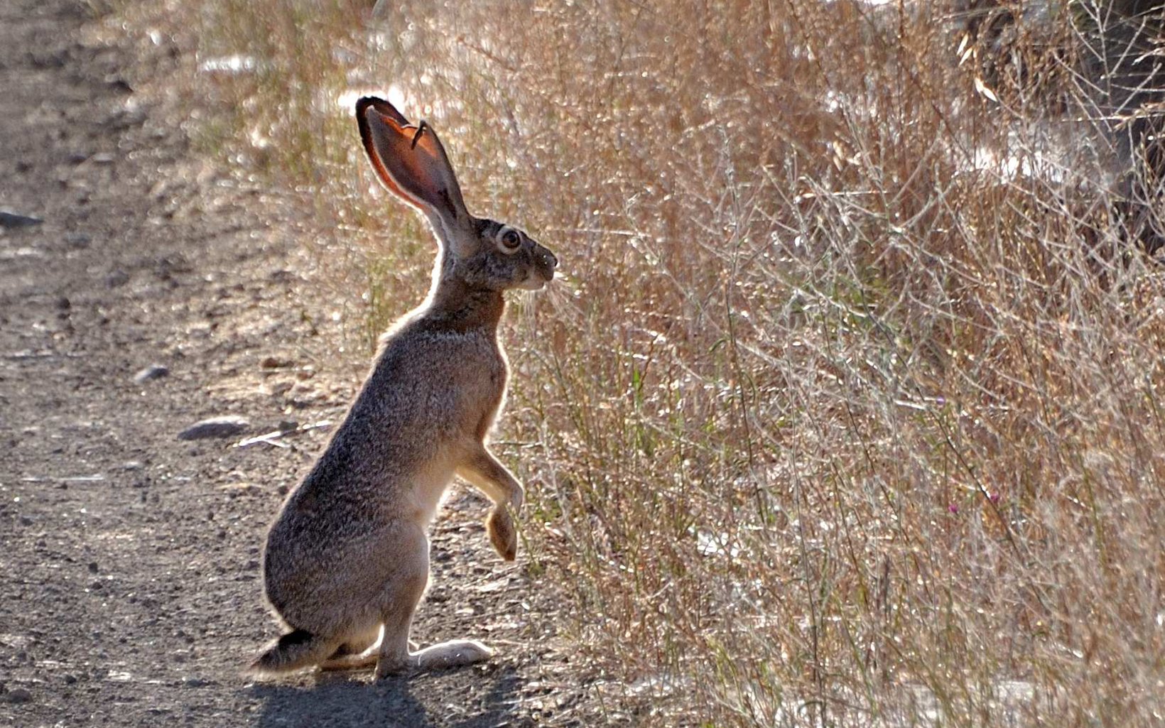
It is common to see the black-tailed jackrabbit along this section of the trail. Settlers in the western U.S. called it a “jackass rabbit” because its enormous ears look like those of a donkey. While they may look odd, those large ears are extraordinarily useful, helping jackrabbits detect audible threats from far away and dissipating heat when the temperature rises. Black-tailed jackrabbits have powerful hind legs; they can leap up to 10 feet and run up to 40 miles per hour, zigzagging to avoid predators. Baby black-tailed jackrabbits are born fully furred with their eyes wide open (unlike cottontail rabbits) and they are almost immediately mobile. Mothers do not protect or even stay with their young except during nursing, but the young are well-camouflaged among the shrubbery and grasses. Litters will typically stick together for about a week after being weaned.
Along the trail, birdwatchers may spot the red-tailed hawk, northern flicker, ladder-backed woodpecker, black-throated sparrow, crissal thrasher, verdin, brewer’s sparrow, American kestrel, raven, loggerhead shrike, Bewick’s wren, bushtits, ash-throated flycatchers and cactus wren. Species of special concern found in the area include the Townsend's big-eared bat, California leaf-nosed bat, Swainson's hawk, golden eagle, desert tortoise, Bendire's thrasher, gray vireo and phainopeplas.


At the 0.8-mile mark you enter an area burned by the York Fire and the remainder of the trail is in the fire zone. This human-caused fire occurred in July and August of 2023 and burned 93,078 acres, mostly in Mojave National Preserve and Castle Mountains National Monument, but also 9,127 acres in Avi Kwa Ame National Monument. A Burned Area Emergency Response team has worked with the Bureau of Land Management and the National Park Service to create a post-fire restoration treatment plan for this area. Unfortunately, areas affected by the fire are expected to face challenges to natural recovery and will take many decades to regrow. Ideally, a burned area will recover naturally, but this is not always the case. Human-caused challenges like fire suppression and climate change have made natural recovery less likely in many burned areas, including the York Fire.
Joshua trees are threatened by climate change due to ongoing drought and changing weather patterns in the Mojave Desert. Experiencing a wildfire makes them more susceptible to mortality, especially the eastern Joshua tree found in this area. Eastern Joshua trees branch closer to the ground and are less likely to sprout from their root systems than western Joshua trees. Research is showing that Joshua trees that have more than 30% of their above-ground material scorched will have a survival rate of only 30%.
At the 1-mile mark, you cross a small wash with lots of catclaw acacia, half burned and half surviving the fire. In fact, across this entire burned landscape, it is interesting to see areas of habitat that were scorched by the fire and pockets not touched at all.
At mile mark 1.1, you get your first view of an historical corral complex. One of the really important stories in the history of the Avi Kwa Ame National Monument is the influence of cattle grazing. In the first decade of the 1900s, southern Nevada was booming with people looking to find their fortune in gold or silver. Searchlight was a hotbed of activity with one of the largest populations in the state. Gold mining was prosperous, and with the influx of people to the area, supporting businesses sprang up to sell goods to the miners. The Rock Springs Land and Cattle Company, established in the late 1800s, responded to the need for food and other resources in Searchlight and the surrounding region, and at the time, was one of the largest cattle ranches in the country by acreage. The company’s headquarters were in Barnwell, California just across the California border in what is now the Mojave National Preserve. At the time, the northern terminus of the newly constructed Nevada Southern Railway was located there. While local consumption by miners in the area was important to the firm, so too was the capability to transport cattle to other markets via the railroad. Their operation quickly grew to one million acres of grazing land across Clark County, Nevada and southeastern California.
Ranchers developed innovative water allotment systems to widely distribute water from just a couple natural springs. Cows were allowed to roam free throughout the desert, and when it was time to send them to market, cowboys on horseback would track them down and gather them up at corrals. You will see remnants of some of the historical water pipelines along the trail.
In the later 1920s, a multi-year severe drought greatly affected production and the Rock Springs Company sold their interests. Several smaller ranches from Rock Springs were formed: the O.X., Kessler, Valley View and Woolf ranches. In 1931, John Woolf sold his ranch to movie stars Rex Bell and Clara Bow, who continued to use the property as a working cattle ranch and as a retreat to escape from the pressures of Hollywood. The Bells sold the Walking Box Ranch to Karl Weikel in 1945, and he continued operating it as a working ranch.
In 1990, the desert tortoise was listed as a threatened species under the Endangered Species Act, and the U.S. Fish & Wildlife Service and Clark County developed a recovery plan that bought out willing ranchers and essentially halted livestock grazing in Clark County. With their livelihood ending, the Weikels sold the ranch. Eventually, the Viceroy Gold Corporation purchase the ranch in 1989 to use as a corporate retreat and headquarters for their gold mine in the nearby Castle Mountains. The property was later sold to The Nature Conservancy and then in 2004, to the Bureau of Land Management. The ranch was listed on the National Register of Historic Places in 2009.
From atop a low bluff, the trail drops to cross a wash. Climbing out, you enter an historic corral that straddles a low rise between this and the next wash. The trail winds through the corral area, crosses and climbs out of the second wash, and passes an old water tank atop the wash bank.
Here you get a much closer look at the jagged Castle Peaks straight ahead (southwest) and a panoramic view looking southeast towards the Castle Mountains. Again, in this section, you see portions of the landscape that were burned in the York Fire and portions that were not.
At mile 1.76, you cross into California and enter Mojave National Preserve.
At mile 2.4 you enter a large wash (arroyo). The trail follows the wash until mile 2.7 where it ends at a second corral. Desert washes are water channels that are typically dry but can fill with waterduring heavy rainstorms, creating temporary water sources. These desert washes are important for the survival of plants and animals in this hot desert environment, as they provide a source of water and habitat. This wash has native desert willows, catclaw acacia and honey mesquite trees. These species are considered phreatophytes, plants with deep root systems that are tolerant of heat and drought. There are also shrubs such as cheesebush, and four-wing saltbushn in the wash.
Mesquite trees have been used as a food source by indigenous groups for centuries. They are part of the legume family and are sometimes called the "southwest superfood". Mesquite pods can be eaten whole, ground into flour, or mashed into a powder. They have a sweet and nutty flavor and are rich in protein and micronutrients like magnesium, potassium, iron, zinc, and calcium. Mesquite sap, can be eaten as a lightly sweet treat or used as a medicine to heal and disinfect small cuts and scrapes. The sap can also be used as an adhesive and paint.
Desert willow trees have willow-like leaves, but they are not true willows – instead they are members of the Catalpa family. Desert willow trees have long, brown, green bean-like pods that grows to about 15 inches long. The fruits mature in autumn, splits in two to release the seeds, and remain on the tree until spring. The pods contain numerous flat, tan seeds and various species of birds and rodents eat the seeds. The willows are notable for their fragrant, trumpet-shaped flowers that bloom in shades of pink and lavender. The flowers attract pollinators, including hummingbirds, bees, and butterflies that feed on the nectar. The sugars in desert willow nectar are a good energy source for these creatures.
Look on the branches of the catclaw acacia and mesquite trees for clumps of desert mistletoe, a parasitic plant with red and white berries. Phainopeplas, a type of silky flycatcher, and mistletoe have a symbiotic relationship that has evolved over time. In the fall through spring, phainopeplas eat the berries of the mistletoe and time their migration into this desert to match the maturing mistletoe's berries. Mistletoe berries may be one of the ultimate superfoods for our feathered friends. All 10 essential amino acids have been found in mistletoe berries as well as lots of carbohydrates. As noted, the berries are red, like the birds' eyes, and the birds often whistle while feeding in the thorny trees. The seeds pass through the birds' digestive system unharmed, and if the droppings land on a suitable branch, the seeds may germinate into new mistletoe clumps. This helps disperse the mistletoe plant while ensuring ripe berries for future generations of phainopepla. While Phainopepla can eat the berries, they are toxic to humans.
Mile 2.7 is the end of the trail and there is another corral area here. The original fenced corral is gone but remnants remain such as a broken windmill, water trough and water tank. This corral complex is tucked into a hillside just off the wash. Although the trail officially ends here, hikers may want to venture up the wash that heads west as it enters a very scenic area and part of the Mojave Wilderness Area. Most of the wash area was not burned and remains a rich environment. Walking up this wash and staying left at forks also leads you to the base of the Castle Peaks.
KNOW BEFORE YOU GO:
Be sure to take plenty of drinking water. Staying hydrated on your hike is of utmost importance. There is no water available along the trail. In the hot summer months, temperatures can reach over100 degrees, even though the hike is at an elevation over 4,000 feet. On a hot day, you should be drinking 1 quart of water per hour of hiking. After half of your water is gone when hiking, turn around and head back. Drinking water before hiking can help reduce the risk of dehydration, as well as drinking during the hike (don't wait until you feel thirsty). Bring electrolyte replacements such as sports drinks or salty snacks. Bodies not only suffer from lack of water, but lack of electrolytes as well.
Remember this is a remote area and cellular service is spotty. There are no services so make sure to fill up with gas before heading out and make sure your vehicle is in good operational condition with a full-size spare tire and a jack.

DIRECTIONS AND PARKING:
From Las Vegas, drive south on U.S. Highway 95 to Searchlight.
In downtown Searchlight, turn right onto Nevada Highway 164 (Joshua Tree Highway) and drive west for 7 miles to the turnoff for the Walking Box Ranch Road.
The turnoff for the Walking Box Ranch Road is marked by a large kiosk styled Bureau of Land Management sign. The dirt road is wide and well maintained and can be done with a sedan. A dust retardant is often applied to the road. A high clearance or 4-wheel drive vehicle is not necessary exept right after heavy rainstorms.
Drive 7.7 miles to an old cattle corral on the right-hand side of the road. Pull inside the corral and park. The trail (narrow backcountry road) is on your left as you drive into the corral and heads southwest. Note that a different dirt road departs the corral to the northwest. The coordinates for the trailhead are 11S 673788m E and 3918888m N.